
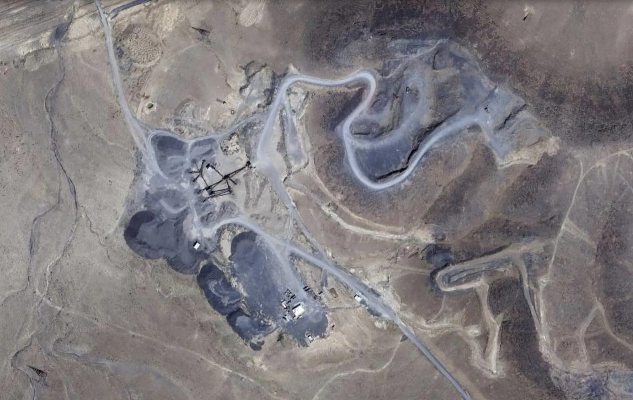
Nangerd Ballast MineNANGERDBahman InfrastructureDevelopment Group
Aerial view of the Nangerd mine

Technical dossier

Nangerd mine specifications

Mine profile
Operator
Bahman Infrastructure Development Group
Mineral
Andesite rubble stone (sang-e lashe)
Province · County
Markazi · Ashtian
Location
26 km south-east of Ashtian, km 50 of the Arak–Qom road, opposite Nangerd railway station
Mine area
191 hectares (1.91 km², quadrilateral A–B–C–D)
Identification code
197462
Exploitation permit
No. 46542, dated 12/12/1393
Discovery certificate
No. 28319, dated 15/07/1393
Confirmed reserve
23,388,750 tonnes, confirmed by the Ministry of Industry, Mines and Trade
Estimated reserve
Over 50 million tonnes
Licensed output
300,000 tonnes per year
Production potential
Over 1,000,000 tonnes per year with the two active crusher lines on site
Extraction method
Open-pit bench mining (three benches), worked by ripper and hydraulic breaker with minimal blasting
Processing
The latest processing equipment available in Iran
Rail access
Branch line within the mine boundary
Road access
5 km to the Arak–Qom road; 55 km to Arak
Railway approval
Ballast approved by the Islamic Republic of Iran Railways
—

Introduction

Mining, as one of the oldest and most important human activities, has played a fundamental role in the development of civilisation and industrial progress. From ancient times to today, the extraction of minerals has been a vital source of raw materials for industry, from the first tools to advanced technology. Mines not only supply resources such as metals, coal, oil, gas and precious stones; as the engine of many economies they also bring employment and economic growth.

Mining has always faced challenges such as environmental issues, worker safety and sustainable management of resources. With advances in technology and environmental awareness, the industry has moved toward more sustainable and responsible extraction, to balance the use of natural resources with the protection of the environment. The study and operation of mines therefore requires specialist knowledge of geology, mining engineering, the environment and economics.

Mineral reserves play a fundamental role in a country's industrial independence and foreign-currency income. Markazi Province, as part of the Urumieh–Bazman magmatic belt and the Sanandaj–Sirjan zone, has notable metallic and non-metallic potential and a long mining history: some 380 mines are worked there — non-metallic and industrial minerals (barite, kaolin, feldspar, bentonite, red earth, silica, ochre, talc, fluorite, dolomite), building materials (lime, gypsum, conglomerate, travertine, marble, granite) and metals (iron, lead and zinc).

Railway track is always under severe stress, from heavy freight trains to high-speed passenger services. The track carries the weight of the vehicle and guides it at the same time; the vertical and horizontal forces bear heavily on the rail, the sleeper and the ballast, and must be studied in both static and dynamic conditions to build a safe and reliable line.

1-1

General information & background

The Nangerd mine, with a confirmed reserve of more than 20 million tonnes of mineral, lies in Ashtian County near Nangerd railway station. Branch line within the mine boundary. The mine is 5 km from the Arak–Qom main road and 55 km from Arak, so it is also accessible by road. Its proximity to the provincial centre, Ashtian County, the new city of Amir Kabir, the town of Karchan and developing villages such as Amrabad, Ebrahimabad and Shahsavaran — all in urgent need of materials — is expected to create a good market for its products.

The operator estimates annual sales at 300,000 tonnes; if the market allows, the two active crusher lines on site can produce more than one million tonnes a year.

Licensing history

  • 1391: end-of-exploration report registered, and approved in 1392
  • 15/07/1393: discovery certificate No. 28319 issued
  • 20/09/1393: first exploitation plan registered
  • 12/12/1393: exploitation permit issued — 1.2 million tonnes confirmed and 25 million tonnes probable reserve, 50,000 t/yr capacity
  • 23/09/1396: permit transferred to Bahman Infrastructure Development Group; in the extension plan annual extraction rose to 200,000 t
  • 1399: permit extended for six years, from 12/12/1399 to 12/12/1405
  • 1400–1402: exploration during extraction; end-of-operations report approved on 06/03/1402 and an allocation of 23,388,750 tonnes of andesite rubble stone agreed
  • 1403: this plan raises annual capacity to 300,000 t and adds two crusher lines
1-2

Boundary & coordinates

Based on the staking carried out, the mine boundary — identification code 197462 — is a four-sided ABCD area with a total area of 1.91 km², located 26 km south-east of Ashtian, postal code 3963135517. The corner coordinates are given in the table below.

CornerLatitudeLongitude
A34° 18′ 50.51″ N50° 11′ 30.28″ E
B34° 19′ 38.71″ N50° 11′ 30.28″ E
C34° 19′ 38.71″ N50° 10′ 39.98″ E
D34° 18′ 50.51″ N50° 10′ 39.98″ E
1-3

Location & access

From Arak

Head toward Qom; 17 km after the new city of Amir Kabir, at km 52 (before the Gandomzar petrol station) take the U-turn toward Arak; after 2 km turn right onto the side road, and after 5 km you enter the mine area.

From Ashtian

Head toward Qom; on reaching the Arak–Qom road turn toward Arak, and after about 10 km you reach the mine road.

1-4

Ashtian — geography & history

Ashtian is the centre of Ashtian County in Markazi Province and was part of historic Iraq-e Ajam. The county is bounded by Tafresh and Qom to the north and by Arak and Mahallat to the south, covers 1,348 km², and has one town, one district and three rural districts. Ashtian is one of Iran's ancient towns: it appears in the History of Qom (378 AH) as Abarashtajan; the name is linked to fire temples of the Zoroastrian era and means a place of worship. The region was part of Lower (Great) Media, and forts from the Median period are still seen there.

The town lies in a relatively cold zone on the slopes of the Ashtian range, overlooking the Zagros heights to the west; at 2,120 m above sea level it is the fourteenth-highest town in Iran. Its winters are cold and mountainous and its summers mild. Nearby peaks include Kolaheh (3,084 m), which separates Ashtian from Tafresh, Zirgan (2,640 m) and Mount Mirab (2,815 m), the natural symbol of the county.

The main water sources are the seasonal Ashtian river, several other seasonal rivers and a few springs, with a considerable number of qanats and deep and semi-deep wells. Two asphalt roads leave Ashtian: 35 km south-east to Rahjerd on the Qom–Arak highway, and 14 km north-west to Abad on the Tafresh–Farahan–Arak road.

1-5

Mazraeh-No village

The village of Mazraeh-No, in the Mazraeh-No rural district of Markazi Province, lies on a plain and is served by asphalt roads. With about 623 inhabitants in 225 households, it has a sports ground, a sports hall and a mosque, piped gas, internet access and public transport.

1-6

Climate & water

Ashtian's climate is cold and dry. The rainy period usually runs from early Aban to mid-Khordad, with an average of 265 mm a year. The cold season is relatively long, from early Aban to late Farvardin. Ashtian is windy, lying between relatively high mountains to the north and the Mighan desert to the south.

The climate of Mazraeh-No follows that of Ashtian: cool, mild springs; hot, dry summers above 30 °C; autumns that bring rain; and winters that fall below zero with snow cover. The town's main water source is the seasonal Ashtian river, formed by two seasonal branches — the larger, the Ahu, rises in the Kolaheh valley — which flows past Siavashan and Dastjerdeh into the Mighan desert.

1-7

Flora & fauna of Ashtian

Being mountainous and semi-arid, Ashtian has vegetation adapted to low water.

  • Rangeland plants: milkvetch (gavan), sagebrush (dermaneh), chubak and other drought-resistant species
  • Trees and shrubs: mountain almond, wild pistachio (baneh), arzhan and hawthorn
  • Medicinal plants: thyme, kakuti, borage and liquorice
  • Crops: wheat, barley and other crops near the villages

Wildlife includes mammals such as wild sheep, ibex, wolf, fox, hare and porcupine; birds such as chukar, see-see partridge, quail and raptors (eagle, owl, falcon); reptiles; and insects. The Kolaheh no-hunting area covers 19,126 hectares, north-east of Gorkan village, and is home to 27 of Iran's 170 mammal species — including wild boar, Arak wild sheep, Pallas's cat, wild goat, wolf, jackal and fox — together with 72 bird and 49 reptile species. The mine area is near the Haftad-Qolleh protected area. Overgrazing, illegal hunting and climate change threaten the region's biodiversity, which needs proper protection and management.

2-1

Geography of Markazi Province

In the first millennium BC Markazi Province was part of Great Media and one of the oldest settled regions of the Iranian plateau. It lies between the Alborz and Zagros ranges, next to the Central Desert, between 33°30′ and 35°35′ N and 48°57′ and 51°00′ E, bounded by Tehran and Qazvin to the north, Isfahan and Lorestan to the south, Isfahan and Tehran to the east and Hamedan to the west. It covers about 29,152 km² and its centre is Arak. Its highest point is Shahbaz peak (3,388 m) in the Rasvand range and its lowest a plain south of Saveh (950 m). About 38% of the province is semi-desert.

About 19% of the province is farmland, 57% rangeland and the rest non-agricultural land such as lakes, deserts, roads and towns. The economy rests, in order, on services, industry and agriculture. Major industries include machine-building, aluminium, helicopter, cable, wagon, combine-harvester, tyre and sugar manufacturing; notable handicrafts are Sarough carpets of Arak and Mahallat, Saveh rugs, Tafresh kilims and jajims, Arak giveh and copperware. Tribes such as the Shahsavan, Kalhor and Khalaj live in the province.

2-2

Geology of Salafchegan & the region

Iran's geology is structurally complex, with zones ranging from late Precambrian metamorphic rocks to Tertiary magmatic complexes. Its present structure formed through Cenozoic orogenic and magmatic activity resulting from the convergence of the Arabian plate and central Iran and the closure of Neo-Tethys, dated to the Miocene. Tertiary volcanism took place mainly in three magmatic belts — Urumieh–Dokhtar, Alborz and western Iran. The Nangerd mine lies on the 1:100,000 Salafchegan geological sheet.

The area lies along the Urumieh–Dokhtar magmatic belt. Its igneous rocks — andesi-basalt, andesite, dacite, diorite and quartz-diorite with porphyritic texture — occur in volcanic and sub-volcanic form. The minerals are plagioclase, amphibole, biotite and quartz with pyroxene and traces of potassium feldspar. Widespread potassic, phyllic and propylitic alteration shows the presence of hydrothermal fluids; the magnesium-rich amphiboles and biotites are characteristic of porphyry-copper intrusions.

Rock units

  • Mlm: dark-green marl below and red marl with sandy–silty limestone above; total thickness about 900–1,200 m; Miocene, equivalent to the Qom Formation
  • MPan: dark, brownish andesitic lava 15–20 m thick with porphyritic texture; labradorite–andesine plagioclase phenocrysts; calc-alkaline
  • Mv: dark grey and green lavas 10–15 m thick, porphyritic; plagioclase, clinopyroxene, amphibole and quartz; andesite–trachyandesite, calc-alkaline
  • Plc1: grey tuff, lapilli tuff and tuff breccia of the Pliocene volcanic phase, with conglomerate and sandstone; dipping about 15° south-west
  • Qtr: cream-to-grey massive and bedded travertine about 10 m thick along the Kahak fault

Structural & economic geology

The sheet lies in the Central Iran structural zone. Orogenic movements from the late Cimmerian to the late Alpine shaped the area; folds trend north-west–south-east, following the Zagros and western Alborz, and the Kahak and Kahak–Khorheh faults have been active at least from the late Cimmerian to the Quaternary. Folds include the asymmetric Kharab–Sarhrud anticline; the faults are mainly left-lateral strike-slip. Economic minerals on the sheet include galena (a formerly worked, now abandoned deposit) and barite veins 2–50 cm thick, some of which are currently worked.

Geological map of the mine

The mine's geological map was prepared from the official map of the Geological Survey and Mineral Exploration of Iran. After prospecting, a frame was defined within the licence area and a 1:1,000 geological and topographic map of the Nangerd mine was drawn.

3-1

Andesite

Stones are natural resources used for many purposes, and the road and building industries are their largest users. Andesite is an igneous rock widely used in road and building work. It is rich in plagioclase feldspar and may contain biotite, pyroxene or amphibole; it usually lacks quartz and olivine and is typically found in lava flows from stratovolcanoes. It is made of fine crystals because lava cools rapidly at the surface — sometimes so fine they can only be seen under a microscope. Rapidly cooled andesite can contain glass; andesite from gassy lava is vesicular or amygdaloidal, when the gas cavities are filled by zeolite.

Where andesite forms

Andesite and diorite are common continental-crust rocks above subduction zones, formed when an oceanic plate sinks and melts. Diorite crystallises underground; andesite is the same magma erupted and cooled quickly at the surface. Both are intermediate between basalt and granite. The name comes from the Andes; large andesite resources occur in Central America, Mexico, Washington and Oregon, Japan, Indonesia, the Philippines, New Zealand and the Caribbean, and andesite can also form at mid-ocean ridges, oceanic hot spots and where magma melts continental crust.

Properties

Besides pyroxene and plagioclase feldspar, andesite may contain hornblende; apatite, garnet, ilmenite, biotite, magnetite and zircon also occur. Its silica content is intermediate, 50–65%. It has a porphyritic texture — large crystals visible in a fine groundmass — and is usually grey, lighter than basalt, with a Mohs hardness of 7. The andesite of the Nangerd mine has a specific gravity of about 2.7. Iron oxide gives reddish-brown andesite, pyrite yellow or golden, hornblende or epidote greenish, and magnetite black.

  • Very high resistance to cold and heat, so usable in any climate, even severe cold and high humidity
  • High quality, strength and light weight at a reasonable price compared with other stones
  • Lighter and more durable than granites
  • Bonds fully with mortar
  • Its lustre and beauty increase with age
3-4

Rubble stone, sand & gravel

Rubble stone (sang-e lashe) is stone that cannot be used as decorative stone but can be used to produce sand and gravel, build walls, in bridges and as railway ballast; in rubble-stone plants it is also used to make stone powder. Building stones used as rough-dressed stone or in irregular shapes for foundations, walls and bridge piers are rubble stone; quarries that do not yield block or cut stone are worked as rubble-stone quarries.

Sand and gravel result from crushing rock naturally or with crushers. Grains smaller than 6 mm are sand, 6–12 mm pea gravel (nokhodi), 12–25 mm almond gravel (badami), and larger grains up to 60 mm ballast. Sand and gravel form the main part of concrete and are used across building, road-building and services: sand–cement mortar for brickwork, mosaic and tiling; gravel of various sizes under ground-floor slabs against rising damp; a layer of non-calcareous sand around service pipes; and in embankments, filters, glass-making and mosaic-making. From subgrade to asphalt surfacing, sand and gravel are the backbone of road construction.

Natural and manufactured

Natural sand and gravel form in seas and deserts by waves and wind — such as river sand and wind-blown sand, which is washed before sale to remove soil. Natural supply cannot meet industrial demand, so most sand and gravel used in construction is manufactured by machine. With natural material the rock type is not in our control; with crushed material the quarry can be studied and the stone chosen. The best stones are granite and siliceous rocks, and in general the denser and heavier the stone, the better it is for concrete and road-building.

Requirements for the stone

  • Uniform, free of earthy veins, with a specific gravity of not less than 1.5 g/cm³
  • Not porous or locally decayed, and not reactive in the chemical hardening of cement
  • Must not change shape or volume in water; absorption must not be so low that mortar cannot bond
  • Resistant to heat, cold and frost, and to abrasion, impact and other loads on the structure
  • Free of clay, silt and other fines; gypsum, anhydrite and all sulfates must be avoided
  • Free of salts that attack steel — such stone must not be used in reinforced concrete

Manufactured sand & gravel production

Quarried stone is taken to the plant, washed or cleaned of impurities, and crushed to size in primary, secondary and tertiary crushers. The main equipment is:

  • Jaw crusher — the first machine in the line; crushes all kinds of rock between a moving and a fixed jaw
  • Kubit (impact) crusher — reduces the jaw output further with hammers on a rotor that throw the stone against the anvil
  • Sand makers — crushers that reduce stone much further for other industries (pocket, rabbit and rock-on-rock types)
  • Sand washer — removes soil from the stone to raise product quality
  • Dryer — removes moisture after washing
  • Conveyor belts — move product, speed up the line, reduce damage and let daily output be estimated
3-8

Ballast

Ballast is a layer of crushed stone with an average size of 20 to 60 mm on which the sleepers and rail rest. It is essential to:

  • Bear the vertical, horizontal and lateral forces on the sleepers and hold the track in its set position
  • Provide part of the track's resilience and energy absorption
  • Spread and transfer loads to the lower layers
  • Distribute loads over the underlying layers
  • Drain surface water
  • Allow the rail to be levelled during laying and maintenance
  • Damp shocks, vibration and noise from rail vehicles
  • Insulate the layer below against frost
  • Prevent plant growth in the track

The properties that define the quality and life of ballast are waste content, frost resistance, resistance to abrasion and wear, soundness, specific gravity and porosity, and dry and saturated compressive strength. Their acceptance limits and the laboratory results for Nangerd ballast are set out on the Tests page.

See the ballast tests →
5-1

Mining & open-pit methods

Mining methods fall into two groups: surface and underground. Underground methods are used where the deposit lies far below the surface and stripping would be uneconomic. At Nangerd the mineral is at the surface, so the mine belongs to the surface (open-pit) group — one of the most important mining methods, which can be carried out sustainably if environmental and safety principles are respected.

Stages of surface mining

  • Exploration and evaluation — geological study, sampling and analysis to establish quality and quantity
  • Site preparation — clearing vegetation and topsoil, building access roads and infrastructure
  • Winning (breaking) — chosen by the mineral and economics: drilling and blasting for very hard rock, picker (breaker), or direct loading by excavator or loader
  • Loading and haulage — heavy loaders and mine trucks take the material to processing or storage
  • Processing — crushing, milling, separation and washing to remove impurities
  • Reclamation — filling pits, planting and returning the land to natural or other use

Main surface methods

  • Open-pit: for shallow, extensive deposits such as copper, gold and iron; pits 4–60 m across, with sloped walls (batter) and flat benches (berm) to prevent wall failure, and a haul ramp for trucks
  • Quarrying: for building stones — sand, granite, rubble stone, gravel, igneous rocks, limestone and marble; similar to open-pit, but explosives are used only to create a free face
  • Strip mining: mainly for coal in horizontal layers on steep slopes
  • Mountaintop removal: removing the upper part of a mountain to reach the deposit, mainly for coal
  • Highwall mining: an auger-based surface method for coal seams

Advantages and drawbacks

Open-pit mining offers lower cost than underground mining, greater safety for workers, higher recovery, easy mass production, selective extraction, a smaller workforce, no limit on machine size and easy drainage. Its drawbacks are land disturbance, water and air pollution, the need for a large area and the need to rehabilitate the land after mining.

5-3

The crushing system

Crushers reduce the raw material from the mine to the size needed for the next stage. Rocks react differently — some break easily, some turn to powder and some are very tough and abrasive — so the crusher is chosen for the rock's wear, hardness, size and moisture. The crushing surface moves at 0.5 to 1.5 m/s. Crusher types are jaw, cone, impact, hammer and roll. At Nangerd, trucks tip the raw material into the feeder silo and, after crushing, conveyors carry it to the stockpile; the line uses a jaw crusher and a kubit.

Jaw crusher

A fixed jaw and a moving jaw; the moving jaw is driven by an eccentric shaft connected to the motor by belt and pulley. Material is crushed under compressive (sometimes impact or shear) force. The gap at the top is the mouth and at the bottom the throat. A gyratory crusher works on the same principle with two truncated cones, the inner one gyrating inside the fixed outer body.

Kubit (impact) crusher

The kubit breaks stone by the rotation of a rotor — by impact, unlike the hydrocone, which crushes by attrition. The stone enters through the inclined mouth, strikes the rotor, is thrown against the upper wall and breaks, and this repeats until it reaches size. It is used for mountain or river material of 10–15 cm, not for soft materials. The Nangerd line includes an HS10 kubit.

  • Feeder — fully automatic, with manual feeding possible
  • Rotor — the main moving core, carrying 2 to 6 steel blades
  • Anvil — a steel part on the inner wall against which the stone breaks
  • Hammers — mounted on the rotor and delivering the first blow
  • Spare parts — hammers, anvils, roof liner, anvil holder, solid anvil and hammer magazine

Why kubit

  • Easy maintenance — every part can be removed and repaired on site
  • Adjustable — all parts can be set to the rock type, size and material
  • Spare parts readily available, avoiding long stoppages
  • Higher crushing power from larger impact surfaces and higher rotor speed
  • Quality product — regular polygonal particles for asphalt and concrete; at Nangerd this keeps the flakiness of the ballast low (the coarser the grading, the higher the chance of flakiness)
  • Lower energy use thanks to the heavy rotor and its inertia
  • High availability because repairs are quick
5-4

How Nangerd is extracted

Extraction at Nangerd is carried out in benches. Given the low relief of the area and access to the highest point, a ramp was designed, three benches were created and extraction started from the top, which raises efficiency. Because the mineral is rubble stone, there is no significant waste; most waste lies in the southern foothills and the watercourses. The surface carries 20 to 70 cm of soil, which is removed by bulldozer before extraction so product quality is not lowered, collected where it can reach the ramp, and loaded by excavator to the waste area.

A second kind of waste is separated during processing: material finer than 4 mm is screened off and taken by conveyor to the waste stockpile, because if these fines stayed in the material they would lower the quality of the sand and base. The crusher line opens onto a face with three benches. Because ballast commands a higher price, the operator aims to raise ballast output, which shapes both extraction and crusher design.

The rock is very hard but, because of numerous faults, completely fractured, so extraction is done by bulldozer and picker. Most production is by bulldozer, which rips the ground and then blades the material into a spot for loading by excavator; zones too hard for the bulldozer are worked with a picker. Ten-wheel trucks carry the load to the crusher silo; each loading cycle takes 15 to 20 minutes on average. The crusher then turns it into ballast, almond gravel, pea gravel and sand. Not blasting, together with fast extraction by bulldozer and picker, has markedly reduced winning costs. Exploration in 1399 showed the same properties down to 24 metres.

The mine covers a very large area (190 hectares) and its reserve is forecast to exceed 50 million tonnes, of which more than 23 million have been confirmed by the Ministry of Industry, Mines and Trade. Given this potential, the operator plans to add two crusher lines and open two new faces.

Dust control & water

To prevent dust and air pollution the crusher needs water; the operator holds a permit for one surface well producing 6,000 to 10,000 litres a day. The new lines may need further wells, to be obtained through the proper legal process.

5-6

Benches, advance & haulage

Benches

  • Bench 1 (top): the widest bench, up to 300 m long and 5–30 m wide; worked out in the middle, with a 10 m strip kept as the access ramp; active on its left and right. The ramp is itself mineral and can be recovered.
  • Bench 2: the best material in the mine — larger blocks that yield a higher share of ballast after crushing; up to 100 m long and 20–50 m wide.
  • Bench 3: not yet complete; it advances as bench 2 advances. The more benches, the shorter the haul to the crusher silo and the loading cycle.
  • Bench face slopes are 50–75°; given the fractures in the rock, the slope should not exceed 75° for safety.
  • Opening a fourth bench will require removing the bench 1 access ramp and building a new ramp in the south.

New lines

Two more crusher lines are planned, each with its own contractor and its own face, also worked from the highest level. Their faces are designed for a loading cycle of about 10 minutes: the point nearest the crusher silo is opened first, then three benches reach the top, after an initial access ramp is built in the south.

Direction of advance

Each face has its own contractor working in an assigned area under the technical manager. The crusher lines are in the south of the mine and the faces advance northward; at the end of the hill the face height is reduced.

Haulage & waste

Loading is by excavator and haulage by truck or dump truck; benches 2 and 3, being closer to the crusher silo, have shorter cycles. After processing, the product is stockpiled by loader near the crusher discharge belts. There are two kinds of waste: surface soil, collected by bulldozer and stockpiled north of the crusher, and the 0–4 mm fines from the first screen, stockpiled south of the crusher. Stripping for the second and third lines can be used to level the crusher area, saving cost and time.

Source: Nangerd operating-licence extension plan, Bahman Infrastructure Development Group, Winter 1403.